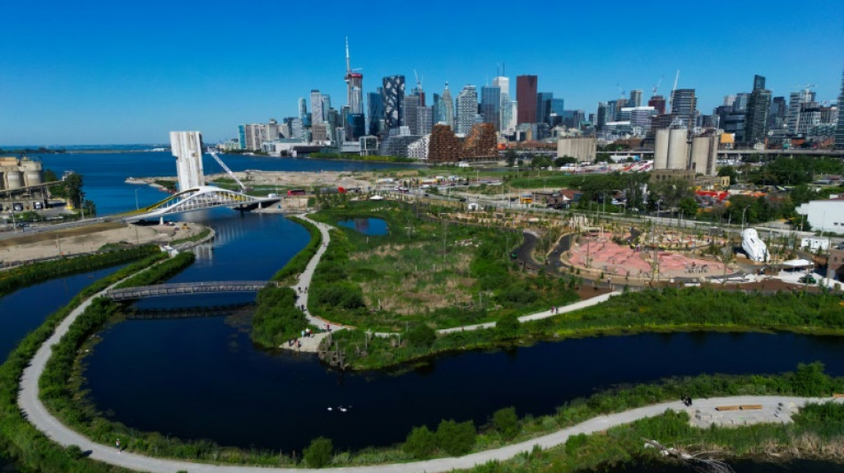
Canada project reclaims 'foul' industrial area to contain floods / Photo: © AFP
 London

 Manchester
 Glasgow
 Dublin
 Belfast
 Washington
 Denver
 Atlanta
 Dallas
 Houston Texas
 New Orleans
 El Paso
 Phoenix
 Los Angeles
San Diego
San Francisco
Chicago
Minneapolis
Seattle
Portland
Salt Lake City
Las Vegas
Miami
Jacksonville
San Antonio
Bermuda
Nassau
Iqaluit
Yellowknife
Anchorage
Fairbanks
Barrow
Calgary
Edmonton
Winnipeg
Goose Bay
Halifax
Boston
Ottawa
Toronto
Detroit
Cleveland
New York
Baltimore
Philadelphia
Nuuk (Godthåb)
Hong Kong
Singapore
Melbourne
Canberra
Adelaide
Darwin
Perth
Fort Worth
Honolulu
Sydney
Johannesburg
Dubai
Mumbai
Zürich
Tokyo
Seoul
Delhi
Beijing
Riyadh
Prague
Pennsylvania
Valletta
Manama
Warsaw
Stockholm
Los Angeles
San Diego
San Francisco
Chicago
Minneapolis
Seattle
Portland
Salt Lake City
Las Vegas
Miami
Jacksonville
San Antonio
Bermuda
Nassau
Iqaluit
Yellowknife
Anchorage
Fairbanks
Barrow
Calgary
Edmonton
Winnipeg
Goose Bay
Halifax
Boston
Ottawa
Toronto
Detroit
Cleveland
New York
Baltimore
Philadelphia
Nuuk (Godthåb)
Hong Kong
Singapore
Melbourne
Canberra
Adelaide
Darwin
Perth
Fort Worth
Honolulu
Sydney
Johannesburg
Dubai
Mumbai
Zürich
Tokyo
Seoul
Delhi
Beijing
Riyadh
Prague
Pennsylvania
Valletta
Manama
Warsaw
Stockholm
The spur to build Toronto's billion-dollar-plus flood prevention project dates back to a devastating hurricane in 1954, but planners say its urgency was reinforced by the recent tragic flooding in Texas.
The Port Lands project has, in part, reversed a consequence of industrialization by reconnecting Lake Ontario with the Don River, more than a century after they were severed to create an industrial area.
Chris Glaisek, chief planning officer at the municipal body Waterfront Toronto, said the idea was to "heal the land from the way it was repurposed 100 years ago," with a focus on "flood protection and naturalization."
The complex project -- one of the largest in Toronto's history with a cost of Can$1.4 billion (US$1 billion) -- included digging a river valley and the creation of two new river outlets, with wetlands and marshes to absorb excess water during extreme storms.
The mouth of the Don River was once the Great Lakes system's largest fresh water marsh, a rich habitat and vital food resource for Indigenous people before colonization.
But Toronto, like many North American cities, saw industrial growth in the late 19th Century.
Much of the marsh was drained and filled in to make room for a port industrial area, while the river was re-routed into a man-made channel.
The Port Lands never thrived as an industrial area, leaving a vast stretch of eastern downtown under-used, and the Don River became polluted.
"It was really dirty, it was foul, it was terrible," Toronto Mayor Olivia Chow said recently.
- Hurricane Hazel -
On October 15, 1954 Hurricane Hazel hit Toronto, after hammering parts of the Caribbean and eastern United States.
It killed 81 people across the Greater Toronto Area and served as catalyst for the city to get serious about flood protection.
Hazel flooded the Humber River, in western Toronto, but Glaisek said "it was understood at the time that that same amount of rainfall, had it landed on the (eastern) Don, would have done a comparable amount of damage."
He called Hazel an initial "impetus" to re-naturalize the Port Lands, but rising awareness over the past two decades about the causal link between climate change and extreme floods helped advance the project.
- 'Duty bound' -
To reclaim the Port Lands, Toronto partnered with the US-based landscape architecture firm Michael Van Valkenburgh Associates, which has worked on the Brooklyn Bridge Park and the Obama Presidential Center in Chicago.
Laura Solano, the lead designer, said the project was "duty bound to address catastrophic flooding," but stressed it offered "much more."
Because the area has been reformed to cope with flood waters, parts have been declared safe for new housing -- an urgent need in the expensive metropolis.
There is also a new park, trails and people can canoe or kayak through the rehabilitated Don.
Solano stressed Toronto's initial decision to alter the area was consistent with the times, when North American cities moved to "industrialize their waters...to raise their economic position."
But now, "every city is looking to reclaim their waters," she told AFP.
The Port Lands "shows the world that it's possible to fix the past and turn deficit and remnant industrial lands into living and breathing infrastructure."
- 'The river is going to flood' -
As Glaisek described the project, he stood on a bank that would, by design, be under water during a major storm.
"It's all planned so that it can flood, the water level can rise, the river can get about three, maybe four times wider than it is now, absorb all of that volume of water," he said.
"When the storm event subsides, it will shrink back down to this."
It's a planning approach that recognizes "we're seeing more and more of these events."
"Like in Texas, you see very tragic outcomes when you haven't really tried to plan for nature," he told AFP, referring to flash floods in early July that killed at least 135 people.
He urged planners to "reposition" their relationship to nature and ditch the mindset that "humans (can) control everything."
"Let's acknowledge the river is going to flood. Let's build the space for it."
H.Zajac--GL